Localised Physical Geography, Geology, Land Formation and Environmental Planning Processes
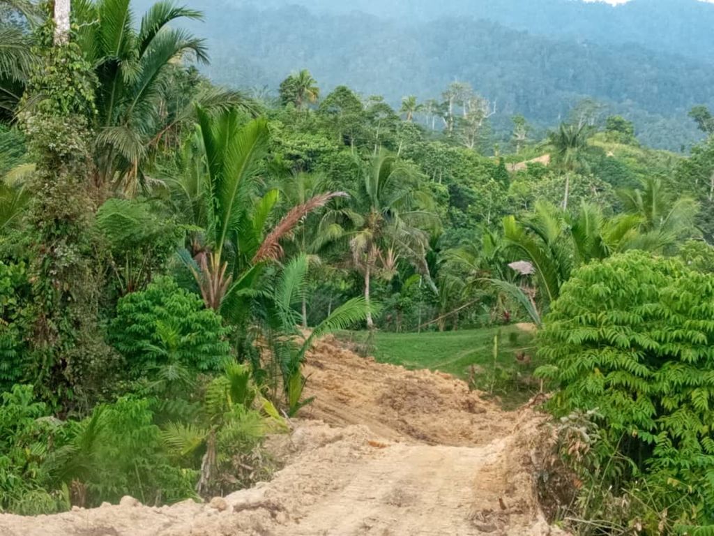
The Project area has undergone a major geomorphological processes in the past 1000 to 10,000 years due to the major water course known as the Screw River having cut a meandering path through the local Maprik Terrain from the north where the river has its source in the Prince Alexander Range to the south in the lower Maprik Basin.
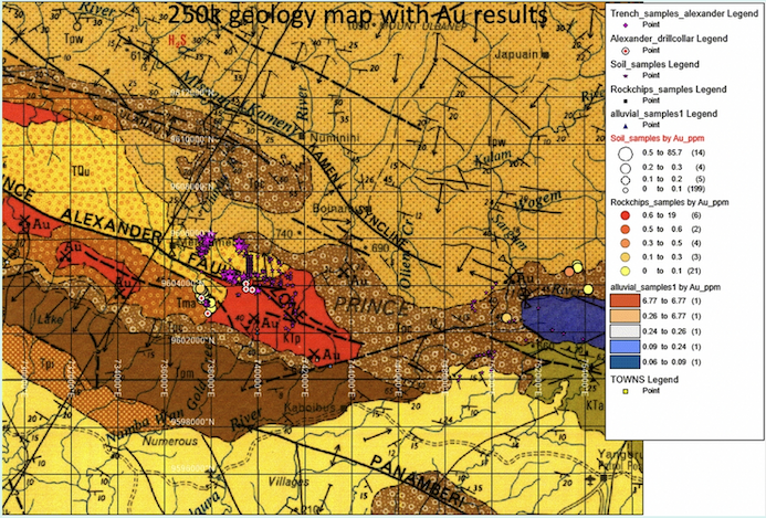
Geological units include, localised volcanic sub units overlain by recent alluvium and quaternary sands and gravels. The local soil structures vary from unconsolidated weathered volcanic loams to deep chloritic green clays with depth profiles up to 5 to 6 meters. Refer to the 1:250,000 geological map extract to the right for the Maprik to Yongaru areas, ESP, PNG showing earlier trench, rock chip, drill holes and alluvial sample locations
The Environmental Assessment and Review Framework (EARF) undertaken by the company in PNG by PGL Gold Pty Ltd provided for a detailed Environmental Protection Plan (EPP) to be implemented as part of the alluvial mining and exploration process to be adopted during the implementation phase of the AML/EL operations due to commence in Q3, 2021
ADB’s Safeguard Policy Statement (2009) are complied with by PGL Gold; The project’s Initial Environment Examination has reviewed to identify the impact for activities during construction and operation of PGL Gold’s proposed alluvial mining and or EL exploration work programme(s). This was included as a generic model but, is a comprehensive environmental management plan (EMP) covering the expected works.
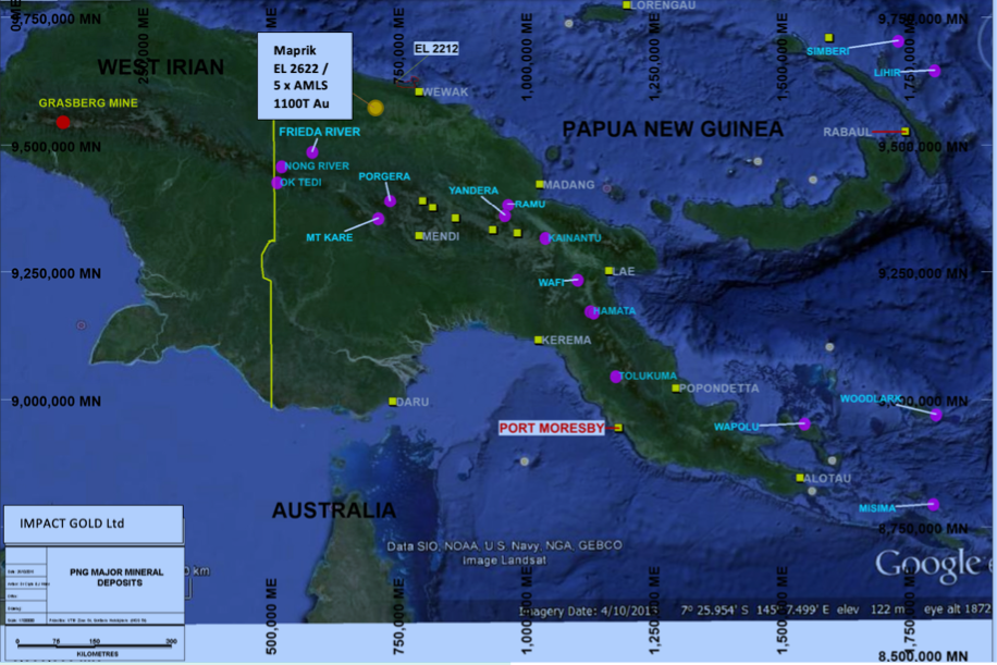
Left: PNG Landsat Map showing Major Mining Projects and area of the companies 5 new AML’s
GEOLOGY AND LAND FORMATION PROCESSES
Geology
The Local geology consists or recent volcanics and detrital alluvial deposits associated with weathering processes including alluvial, elluvial sand and gravel deposits within localised water courses and some older consolidated conglomeratic units pre-compacted by processes of sediment induration.
Geomorphology
The Geomorphology of the Maprik area is that of rolling to steep sided hills with a high degree of vegetation bisected by water courses, primarily the Screw River which constitutes a meandering river, containing large to medium rounded boulders and deep cut channels into river banks from the flow of water primarily during flooding processes where the river banks have been deeply eroded up to 70m in depth.
Alluvial Au Deposits
The primary alluvial gold deposits in the Screw River consists of transported river sands and rounded boulders poorly sorted by the slow moving waters. However evidence exists of major flooding processes within the Screw River where the Alluvium has been transported and moved up the river profile into Levee Banks and loads of alluvium up to 5 or 6 meters deep exist in this profile.
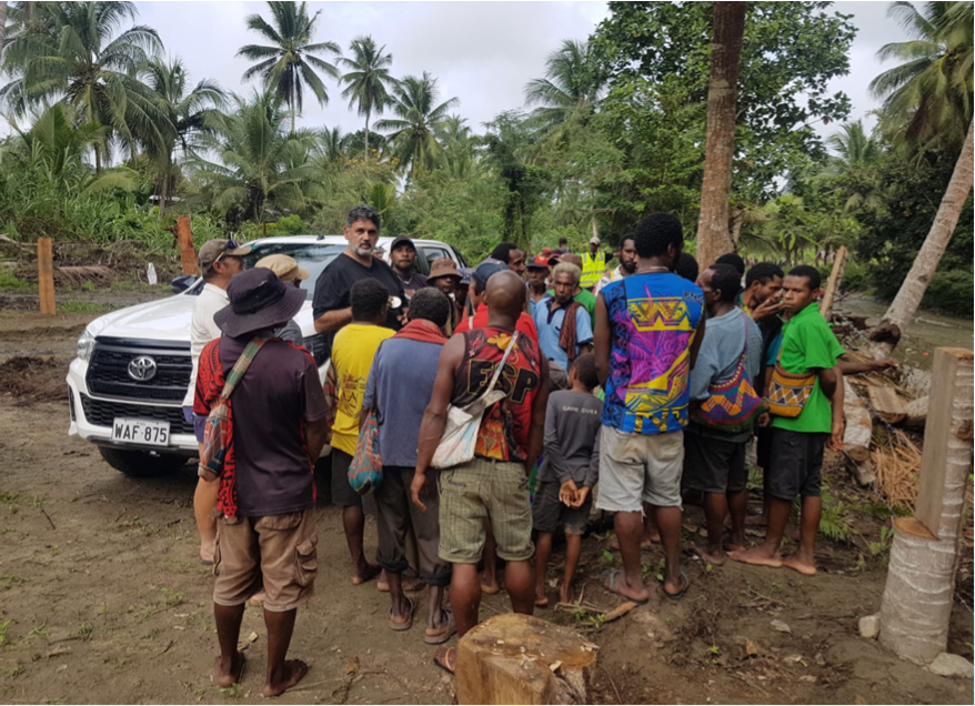
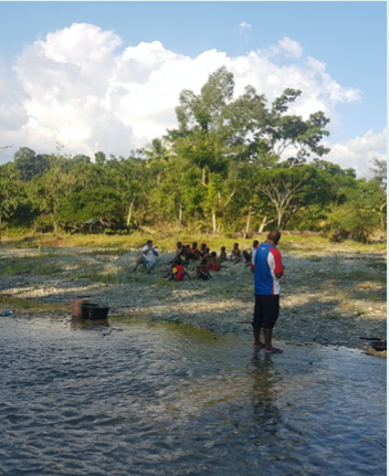
Chief Geologist working with local inhabitants of Maprik to define work plan for days sampling in the field on the Screw River, Maprik, PNG. All sampling, where possible followed industry and JORC standard with locals being paid higher than the normal rural wages for their labour.
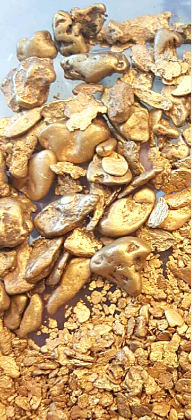
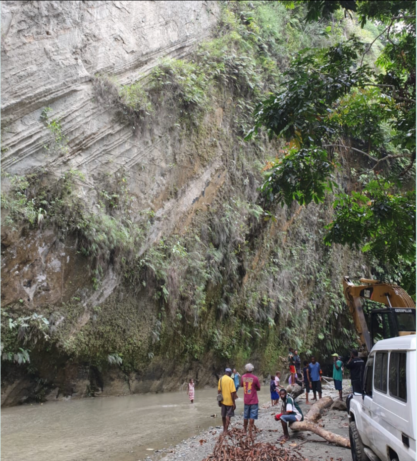
Much of the concentrated gold which has accumulated in the Screw River is due to high energy, intermittent flooding having taken coarse, nuggety gold from its source in the North Maprik region of the Screw River Basin. These nuggets travel downstream through tight, narrow, high sided cliff walls flanking the River bank (refer to the picture below showing steep sided Screw River Cliff face) and which is having the effect over 1000’s of years of a large, natural, geological Sluice which has concentrated pockets of high grade gold on the upward, low energy side of these localised areas of rockfalls.
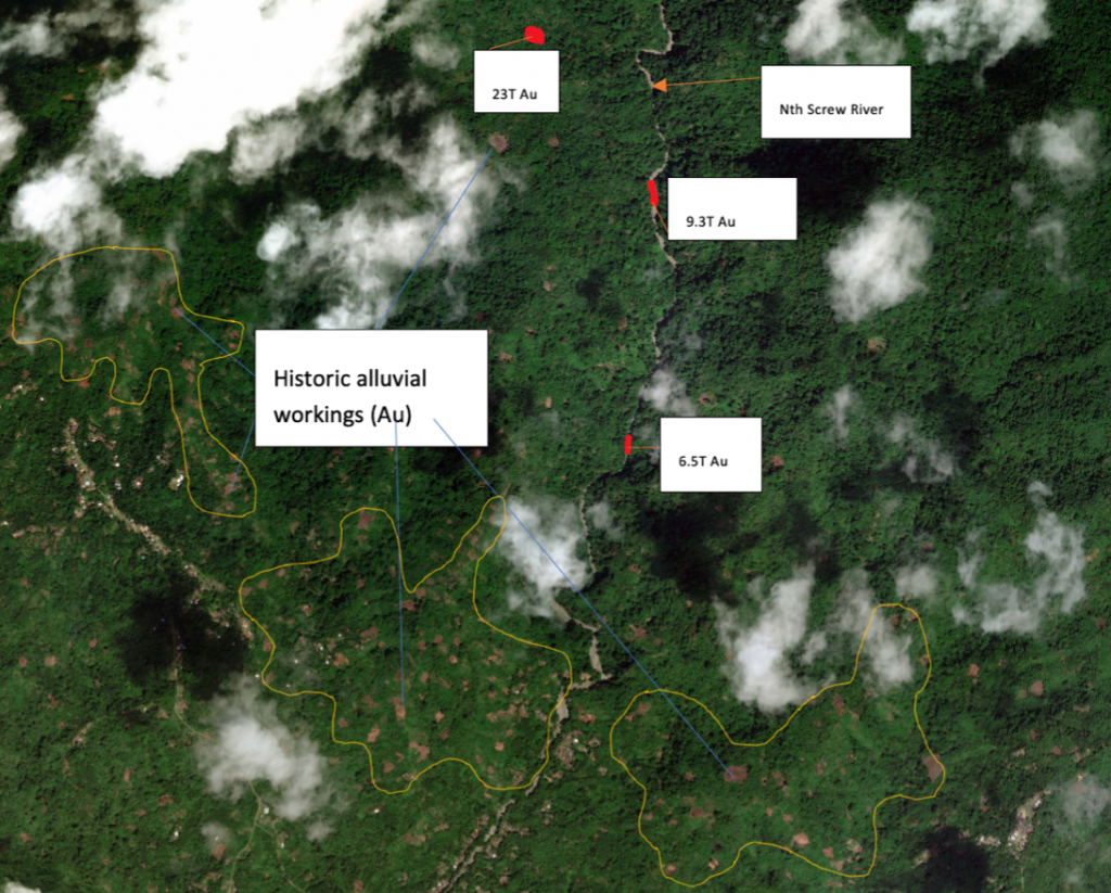
The picture below shows the high sided cliffs typical of the Screw River trace. There are 3 main locations along the Screw River between the northern source and lower reaches where the river traverses the township of Maprik. In this areas, RFGT has identified 3 high grade gold pods which contains in excess of 38Tonnes of concentrated alluvial gold.
At these 3 locations (blockages) in the river, the company has investigated these localities and found that there were super rich gold occurrences in these locations.
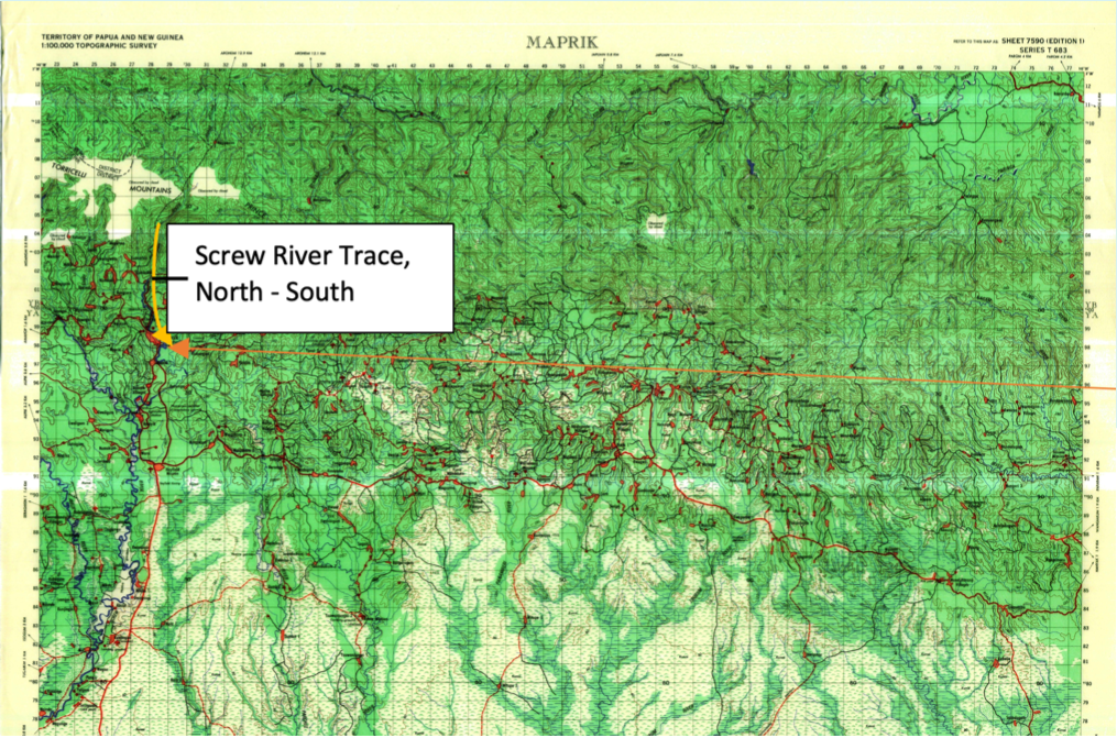
Photo above shows trace of the Screw River in North Maprik, ESP, PNG. Topographic Map showing Maprik township and trace of the Screw River which travels north south from the Prince Alexander Mountain Range down to Maprik.
Historical Background: The Earliest Mining Activity in the Maprik region recorded constitutes a recorded gold rush in and around 50 years ago. The principal target was the Screw River and alluvial hand mining activity was undertaken. Several attempts have been taken in the past 20 years to mechanise the alluvial gold extraction process using small to medium dredging units purchased locally in Wewak or brought in from overseas.
The current level of small scale alluvial mining operations in the area are restricted to Gold panning and washing by individuals and as well as some small scale floating wash plants using 4″ to 6″ suction dredges with attached sluice boxes.
In addition to the above, RFGT has confirmed the existence of a large alluvial gold resources above in the same are.
Maprik Project Overview: The Maprik Goldfield lies 2 1/2 hours outside of the regional central town of Wewak in East Sepik province in PNG. The operating company PGL Gold PTY LTD (PGL) and its wholly owned subordinate, company of Impact Gold LTD (IGL) which controls MOU’s and Tribute agreements over the entire Maprik region now including expired AML’s 602 & 693 over the Screw River where a lot of historical sampling work was undertaken and the newly granted AML’s 873 to 877 where the company will begin its new mining operations. The Screw River bisects the town of Maprik and the Maprik Goldfield.
The super rich, gold resource identified in the alluvials at Maprik exists in both recent alluvial sands and quaternary gravels within the Screw River confines and older eluvial terraces perched above the existing river trace. In addition to the regional geological investigations the company has undertaken a process of securing additional tenure in the Maprik region via its 2nd in time application for new EL Application 2622 which holds it above all other applicants for when this EL is relinquished in late 2021.
ALLUVIAL MINING OPERATIONS AND PNG COMPANY LEASES
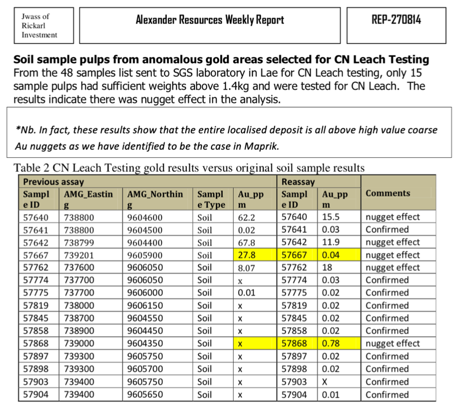
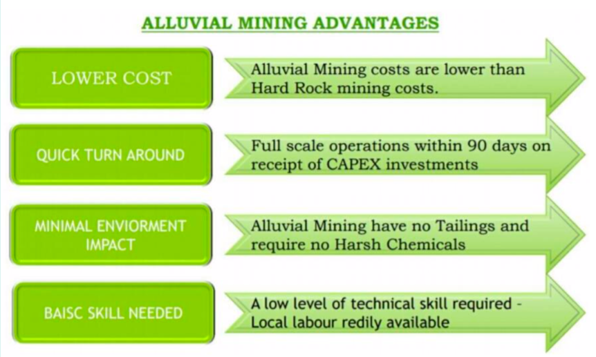
During the pilot plant operations testing in 2017 and 2018 the company determined that high grades of both fine grained and coarse, nuggety gold existed within the Screw River lease area and continues upstream from the AML 693 lease. The company technical team determined that gravity extraction based upon conventional alluvial mining methods was the best option for extracting the Screw River gold. The advantages of this mining methodology are outlined in the figure to the right.
During early 2019 the company began negotiations with local landowners upstread from the town of Maprik. 5 subsequent, binding landowner agreements were signed to deliver 5 new AML’s over the upper reaches of the Screw River where the source of the Screw River Gold is derived. The 5 new AML’s are currently granted by the PNG Mines department MRA to the company as the Tribute Miner.
Mining Plan
Mine Plan: The 5 new AML’s mine plan consists of Bulk mining and sluicing of the alluvial material designated to have the richest grades of gold contained within the Alluvial profile. The selection of the areas to be mined will be undertaken with local knowledge and geological examination and follow-up sampling. The company also retained the use of RFGT technology as an in-house geophysical methodology which has been used in the past 40 years (very accurately) across Eastern Europe, the Middle East, India, South America and Australia so as to determine the locations of high grade, high value alluvial gold deposits as well as other hardrock and sedimentary targets.
The Company also deployed gold concentrating tables for consolidating the sluiced material which may include Gemini and/or Wifley tables and/or High pressure Jigs to collect any alluvial Au nuggets found in the river system.